A familiar CAD workflow
Commands follow real design stages, with clearly organised ribbon modules and direct control in the DWG environment.
CAD tools for road infrastructure
Latest versionDownload →TCM ROADS connects alignment design, vertical geometry, cross sections, intersections and quantities in one clear workflow.
Discover TCM ROADS
From terrain and alignment to profiles and quantities — explore TCM ROADS with the free trial.
TCM ROADS in your CAD environment
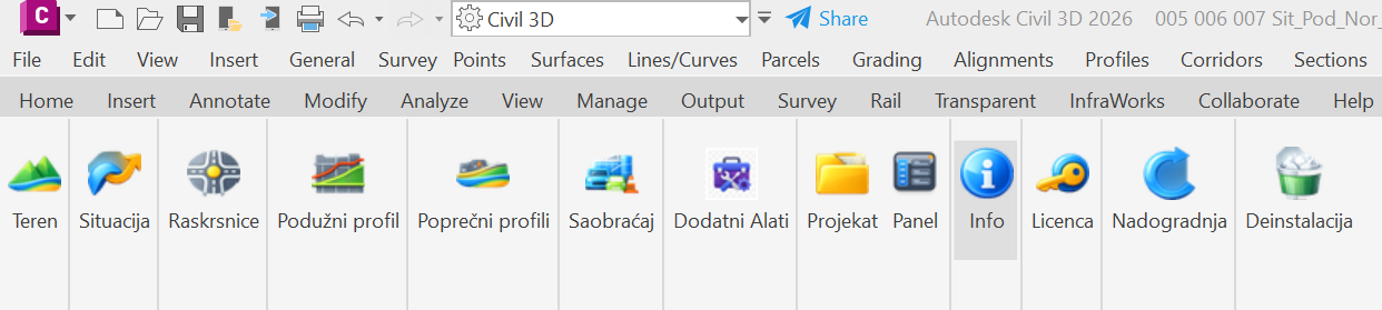
Terrain, alignment, intersections, longitudinal and cross sections — clearly arranged on the ribbon, with access to the project panel and software updates.
One connected system
Geometry changes carry through linked project views, while annotation, quantity and documentation tools speed up everyday tasks.
Commands follow real design stages, with clearly organised ribbon modules and direct control in the DWG environment.
TCM ROADS is developed as a dynamic system: changes in plan view or cross sections are reflected in linked parts of the drawing. Terrain, alignment, vertical geometry and profiles form a coordinated design.
Dimensions, annotations, tables and quantities follow engineering practice and the requirements of the Serbian market.
A modular system
One project, connected modules. Select a discipline to explore its part of the design process.
DIGITAL TERRAIN MODEL
Import and process survey data, select elevation attributes, organise project locations and make local terrain model corrections.
Tools in practice
Explore some of the commands you will use on a project. Launch them from the relevant module or enter their names in the CAD command line.

Terrain
Create a triangulated network from points, with breaklines and terrain boundaries.
TCMTERFACEPoints and boundaries → 3DFACE terrain model.
Terrain
Select block types and the attribute containing the Z elevation.
TCMTERBLOKSurvey blocks → points with elevations.

Plan view
Create an alignment from two selected polylines, with settings in a dedicated dialog.
TCMOS2PLTwo polylines → road alignment.

Longitudinal profile
Open a comparison of vertical alignment alternatives and review different elevation designs.
TCMPROFCOMPAREVertical alignment alternatives → comparison view.

Cross sections
Define pavement layers with a dedicated tool and display them in cross sections.
TCMPOPSLOJLayer properties → pavement structure view.
Annotation
Label cross-section elevations with a choice of symbols and annotation styles.
TCMKOTVISINAProfile points → elevation labels.
Intersections
Start creating a roundabout. The module also includes commands to edit, refresh and manage approaches.
TCMKRUZCRTIntersection parameters → roundabout geometry.
Quantities
Open the volume calculation linked to the cross sections of the selected alignment.
TCMZAPREMINACross-section data → volume overview.
Before using geometry and quantity commands, prepare the required terrain, alignment or profiles in the drawing.
Download the free trialA controlled process
TCM ROADS follows the way engineers work, keeping essential checks and avoiding manual copying between disconnected tables.
Download the free trialImport survey data and prepare the digital terrain model.
Create the route from geometric elements or between existing polylines.
Coordinate elevations, crossfalls and pavement structure.
Present quantities, volumes, dimensions and final design drawings.
System requirements
Straightforward installation and regular updates for your everyday design work.
Latest version
Try TCM ROADS tools on your projects with the free trial version. No payment card is required to download it.
TCM ROADS is available as a free trial so you can explore its features.
Latest release
TCM ROADS is under active development, with weekly software updates. Development includes new tools, improvements to existing commands and greater stability.
Feedback from engineers helps shape the software around real project needs. Follow updates here and download the latest release.
TCM ROADS updates
Explore new features, improvements and fixes in each documented release.
The archive starts with version 2.1.8.2. Earlier releases are not included.
Loading release history…
QUICK START
From installation to your first drawing. Start with a copy of a project and explore the tools at your own pace.
You need 64-bit Windows 10 or 11 and AutoCAD or Civil 3D 2026. TCM ROADS is an add-on that runs inside your CAD application.
The CAD application is installed and licensed separately.
Save your work and close the CAD application. Download the current installer and follow its instructions. Open your supported CAD application and follow the TCM ROADS activation instructions.
Download the free trial and follow the activation instructions.
Work on a copy of your DWG. Prepare survey points and terrain boundaries, then explore terrain, alignment and profile tools in that order. Check the units and elevations before calculating quantities.
Use the command reference below to find the tools you need.
Direct support
Support is grounded in engineering practice. We help with installation, your first project and integrating new commands into your workflow.
Installation, activation and workspace setup.
A practical walkthrough of the modules on a real task.
Regular improvements based on real engineering practice.
Frequently asked questions
Short answers about downloading, installing and using the software.
Yes. A free trial of TCM ROADS is available. No payment card is required to download it.
The “Download TCM ROADS” button automatically takes you to the latest installer from the official update channel.
The current version supports 64-bit Windows 10 and Windows 11, with AutoCAD or Civil 3D 2026.
TCM ROADS is an add-on for a supported CAD application. The CAD application is installed and licensed separately.
Yes. We provide assistance with installation, activation and initial setup.